Forest Degradation
In a context of a political will to fight global warming, REDDiness contributes, on its own scale, to the establishment of a monitoring system of deforestation and forest degradation by remote sensing.
The forest change processes in Central Africa are particularly hard to address by remote sensing due to (Duveiller et al 2008 ): (i) small deforestation areas needing fine scale imagery, (ii) non-uniform distribution of deforestation, (iii) persistent cloud cover, and (iv) high frequency of forest changes. Besides forest conversion (i.e. deforestation), forest degradation by over-exploitation (for fuel wood, selective logging, or slash and burn practices) should also be included in REDD MRV although it is seldom addressed in existing operational projects.
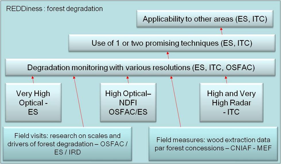
Mapping forest degradation with remote sensing is challenging because degraded forests are generally a complex mix of various land cover types (vegetation, dead trees, soil, shade, and possibly crops) and the spectral signature of a degraded forest can change quickly . Therefore monitoring forest degradation and selective logging needs high to very high spatial resolution. This is usually done either in a direct approach (detecting small clearings) or an indirect approach detecting disturbances like road networks and log decks. Direct methods vary in a trade-off between visual image interpretation and automated algorithms such as spectral mixture analysis (SMA) using sub-pixel classification methods or normalized difference fraction index (NDFI) both applied successfully in the Brazilian Amazon.
Beyond methodology challenges to estimate degradation, there is an issue regarding definitions. An IPCC report suggested and analyzed five definitions of forest degradation but could not agree on one . Congolese plans for REDD+ took the following suggestion from that IPCC report: “Degradation is a long-term loss (persisting for x years or more) of at least y% of forest carbon stocks since time T and not qualifying as deforestation, i.e. the conversion of “forest” land to another land-use category” . We envisage more in-depth discussion on a precise working definition of forest degradation in WP3.
Concretely, the project intends to evaluate different types of satellite imagery for their effectiveness in detecting and potential monitoring of forest degradation. This study will not make the link to carbon emissions, but limit itself in evaluating the potential of different sensors at high and very high resolution to detect when and where forest degradation occurs:
1. Innovative methods of High Resolution forest degradation mapping
The Normalized Difference Fraction Index (NDFI) is a method successfully applied in the Brazilian Amazon to identify and distinguish forest degradation caused by selective logging and associated forest fires from other natural disturbances. Given the general small-scale changes in the central African context (i.e. different degradation processes), the potential of NDFI for Congo and Gabon needs to be examined.
2. Very High Resolution forest degradation assessment
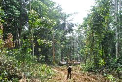
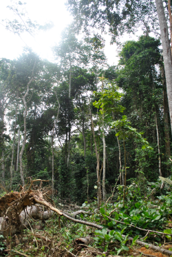
For each site, a degradation assessment is made based on very high resolution data and semi-automatic object based classification. The resulting maps are discussed in comparison of field evidences.
3. Detection of forest degradation by SAR
The main objective is to evaluate the potential and limitations for the detection of forest degradation with SAR satellite data. A main component of the SAR analysis is the visual comparison of the imagery (and derived products) with evidence of forest degradation.
In a context of a political will to fight global warming, REDDiness contributes, on its own scale, to the establishment of a monitoring system of deforestation and forest degradation by remote sensing.
The forest change processes in Central Africa are particularly hard to address by remote sensing due to (Duveiller et al 2008 ): (i) small deforestation areas needing fine scale imagery, (ii) non-uniform distribution of deforestation, (iii) persistent cloud cover, and (iv) high frequency of forest changes. Besides forest conversion (i.e. deforestation), forest degradation by over-exploitation (for fuel wood, selective logging, or slash and burn practices) should also be included in REDD MRV although it is seldom addressed in existing operational projects.
Mapping forest degradation with remote sensing is challenging because degraded forests are generally a complex mix of various land cover types (vegetation, dead trees, soil, shade, and possibly crops) and the spectral signature of a degraded forest can change quickly . Therefore monitoring forest degradation and selective logging needs high to very high spatial resolution. This is usually done either in a direct approach (detecting small clearings) or an indirect approach detecting disturbances like road networks and log decks. Direct methods vary in a trade-off between visual image interpretation and automated algorithms such as spectral mixture analysis (SMA) using sub-pixel classification methods or normalized difference fraction index (NDFI) both applied successfully in the Brazilian Amazon.
Beyond methodology challenges to estimate degradation, there is an issue regarding definitions. An IPCC report suggested and analyzed five definitions of forest degradation but could not agree on one . Congolese plans for REDD+ took the following suggestion from that IPCC report: “Degradation is a long-term loss (persisting for x years or more) of at least y% of forest carbon stocks since time T and not qualifying as deforestation, i.e. the conversion of “forest” land to another land-use category” . We envisage more in-depth discussion on a precise working definition of forest degradation in WP3.
Concretely, the project intends to evaluate different types of satellite imagery for their effectiveness in detecting and potential monitoring of forest degradation. This study will not make the link to carbon emissions, but limit itself in evaluating the potential of different sensors at high and very high resolution to detect when and where forest degradation occurs:
1. Innovative methods of High Resolution forest degradation mapping
The Normalized Difference Fraction Index (NDFI) is a method successfully applied in the Brazilian Amazon to identify and distinguish forest degradation caused by selective logging and associated forest fires from other natural disturbances. Given the general small-scale changes in the central African context (i.e. different degradation processes), the potential of NDFI for Congo and Gabon needs to be examined.
2. Very High Resolution forest degradation assessment
For each site, a degradation assessment is made based on very high resolution data and semi-automatic object based classification. The resulting maps are discussed in comparison of field evidences.
3. Detection of forest degradation by SAR
The main objective is to evaluate the potential and limitations for the detection of forest degradation with SAR satellite data. A main component of the SAR analysis is the visual comparison of the imagery (and derived products) with evidence of forest degradation.
Support Central Africa in Earth Observation driven forest monitoring for REDD
This project is partially funded by the European Commission Seventh Framework Programme. The project reflects only the author’s views and the Community is not liable for any use that may be made of the information contained herein.
PROJECT OUTCOMES