REDD in Gabon
Country description
Gabon covers 262,090 km². In 2005 Gabon was reported to have 1.3 million inhabitants giving an average population density of 5 inhabitants per km².
Gabon has dense forest covering some 21 million ha, more than 80% of the national territory. Three main types of dense rain forest can be distinguished:
- coastal forests (0-300 m): 32.6%,
- intermediary forests (300-1000 m): 66.7%
- flooded forest and mangrove: 0.7%.
The rest of the country is made up of forest-savannah mosaic, swampy zones and mangrove. In terms of deforestation rate, Gabon, the Republic of Congo and the Central African Republic, are among those countries where the deforestation dynamic is still relatively low with an annual rate of 0.09% for a regional average of 0.21% per year (± 0.05%).
Gabon National REDD program
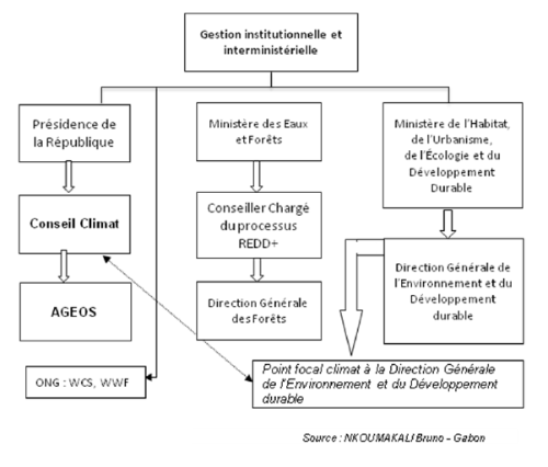
REDD in Gabon is the responsibility of Climate Focal Point (to the UNFCCC) which takes place at the General Directorate of Environment, which depends on the Ministry of Housing, Town Planning, Ecology and Sustainable Development. This focal point is responsible for program execution on climate change funded by the UNDP on the inventory of greenhouse gas (IGES). Another player involved in the management of REDD in Gabon is "Climate Council", under the supervision of the Presidency of the Republic.
The figure below summarizes the involvement of these stakeholders.
In following deliverable (from page 25 onward) more info on REDD in the Gabon can be found (only in French):
Country description
Gabon covers 262,090 km². In 2005 Gabon was reported to have 1.3 million inhabitants giving an average population density of 5 inhabitants per km².
Gabon has dense forest covering some 21 million ha, more than 80% of the national territory. Three main types of dense rain forest can be distinguished:
- coastal forests (0-300 m): 32.6%,
- intermediary forests (300-1000 m): 66.7%
- flooded forest and mangrove: 0.7%.
The rest of the country is made up of forest-savannah mosaic, swampy zones and mangrove. In terms of deforestation rate, Gabon, the Republic of Congo and the Central African Republic, are among those countries where the deforestation dynamic is still relatively low with an annual rate of 0.09% for a regional average of 0.21% per year (± 0.05%).
Gabon National REDD program
REDD in Gabon is the responsibility of Climate Focal Point (to the UNFCCC) which takes place at the General Directorate of Environment, which depends on the Ministry of Housing, Town Planning, Ecology and Sustainable Development. This focal point is responsible for program execution on climate change funded by the UNDP on the inventory of greenhouse gas (IGES). Another player involved in the management of REDD in Gabon is "Climate Council", under the supervision of the Presidency of the Republic.
The figure below summarizes the involvement of these stakeholders.
In following deliverable (from page 25 onward) more info on REDD in the Gabon can be found (only in French):
Support Central Africa in Earth Observation driven forest monitoring for REDD
This project is partially funded by the European Commission Seventh Framework Programme. The project reflects only the author’s views and the Community is not liable for any use that may be made of the information contained herein.
PROJECT OUTCOMES