Project Area
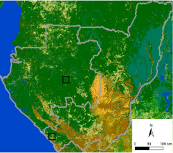
The project areas of REDDiness are localized in the Republic of Congo and Gabon.
In both countries forest occupy a prominent place, with two thirds of the territory in Congo and more than 80% in Gabon. Although, deforestation rates aren’t so high than in South-America for example, conservation of these valuable forests is seen as a priority. More extensive info on REDD+ in the specific countries can be found through the following links: Republic of Congo and Gabon.
To evaluate the potential of different satellite sensors to detect forest degradation, it was decided to select one study site in each country. The two study sites are defined in a nested way: the broader area covers 40x40 km and will be analyzed with high resolution EO data (optical and radar). Within this 40x40 km, one focal area of 20x10 km was chosen for an in-depth analysis with very high resolution EO data (optical and radar). The selection process of the study sites is described in detail in the WP3 report.
For more details about the study site follow this link to the online GIS portal.
Support Central Africa in Earth Observation driven forest monitoring for REDD
This project is partially funded by the European Commission Seventh Framework Programme. The project reflects only the author’s views and the Community is not liable for any use that may be made of the information contained herein.
PROJECT OUTCOMES